Missions Supported by Laser Ranging
 (Credit: NASA/JPL)")
GRACE Follow-On (GRACE-FO) (Credit: NASA/JPL)
Geodetic Satellites
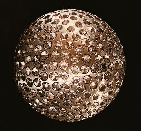 Geodetic satellites are designed to look and act as point-mass objects in order to allow for the most precise computation of their orbits. Big or small, cannonball-shaped, with as small an area-to-mass ratio as possible (to minimize the effect of non-conservative forces), they are passive objects studded with corner-cube retroreflectors (CCRs). Used as targets by Satellite Laser Ranging (SLR) ground systems, these satellites with their very precise orbits, provide very accurate, unambiguous distance measurements. They contribute to geodesy with positioning, determining the shape and size of Earth; and the variations of the terrestrial gravity field. The Lageos satellites are the basis of the ILRS contribution to the International Terrestrial Reference Frame (ITRF). Other geodetic satellites such as Etalon, Starlette, Stella etc are now being added to further strengthen the reference frame.
Remote Sensing Missions
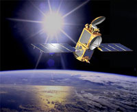 Remote sensing satellites carry payloads that measure structure and ongoing processes on the Earth using electronic and optical sensors (altimeters, gradiometers, satellite to satellite tracking, etc.) These systems measure the environment and monitor change on a global basis. Altimeters measure the topography of the ocean and ice surface to monitor changes on sea level and ice volume. Gravity field measurements help us understand the structure and dynamic processes within the Earth including changes surface hydrology, mass shifts, etc. Atmospheric and Ionospheric sensors help us understand the structure of these media and the dynamic process within. SLR is used to calibrate, validate, and monitor many of these systems and is a contributor to POD. SLR has also provided full POD in several cases when the radio systems have failed.
Global Navigation Satellite Systems (GNSS)
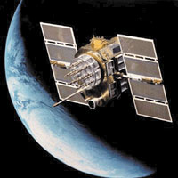 GNSS satellites are launched in constellations to provide accurate positioning and velocity for land, sea, air and space applications. Ground surveys today are based on GNSS and nearly every vehicle has or will have GNSS to monitor its motion and plan its future path. Science has adopted GNSS as a fundamental tool for measuring ground motions, Earth rotation, ionospheric and atmospheric structure (using occultation), and a host of other uses. SLR is used to calibrate the GNSS orbits and the combination of GNSS and SLR will be used to distribute the reference frame for users worldwide. Retroreflectors have been placed on satellites in the GPS, GLONASS, Compass, and Galileo (GIOVE) constellations. The apparent trend is to place arrays on many more. New complexes underway in India and Japan will also include arrays.
Experimental Satellites
 Experimental satellites are a catchall for demonstration payloads that do not fit easily in any one of the other mission classifications. These satellites can often be in relatively low altitude orbits. RadioAstron is an exception. Some of these satellites have only SLR for tracking to save space and power. These satellites are often small in size and weight, irregularly shaped, and low cost. Some examples include TIPS, Starshine, Reflector, LRE, ANDE, and RadioAstron. The ILRS has thus established a CCR array standard which provides guidance in designing the correct array for each application.
