Quick Links

Recent News
This page contains all recent ILRS news. For those interested in news specific to satellite missions, please visit our Mission News page.
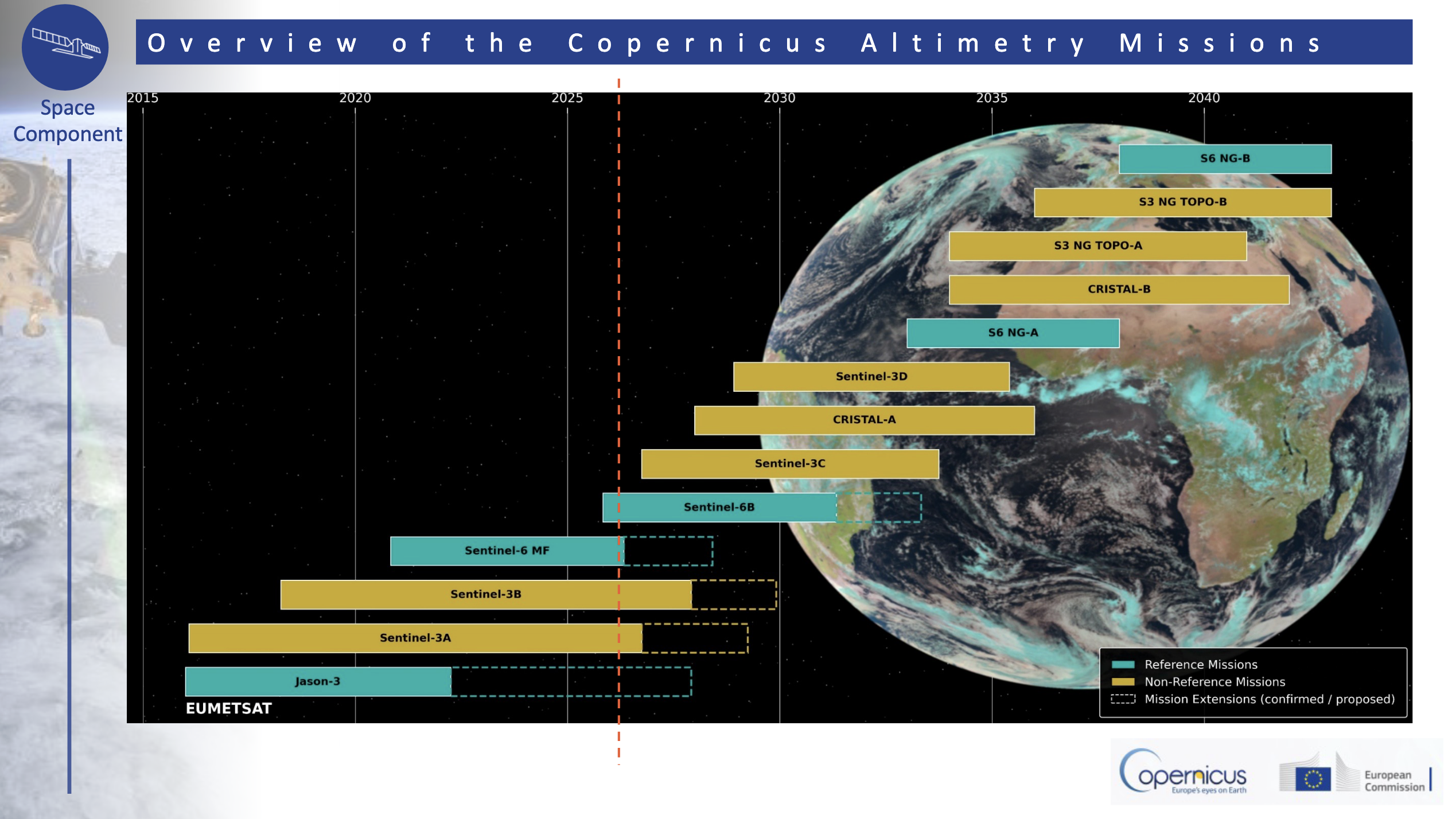
See the Figure below from (Cacciari, 2026) for a summary of the Copernicus altimetry missions, present and future.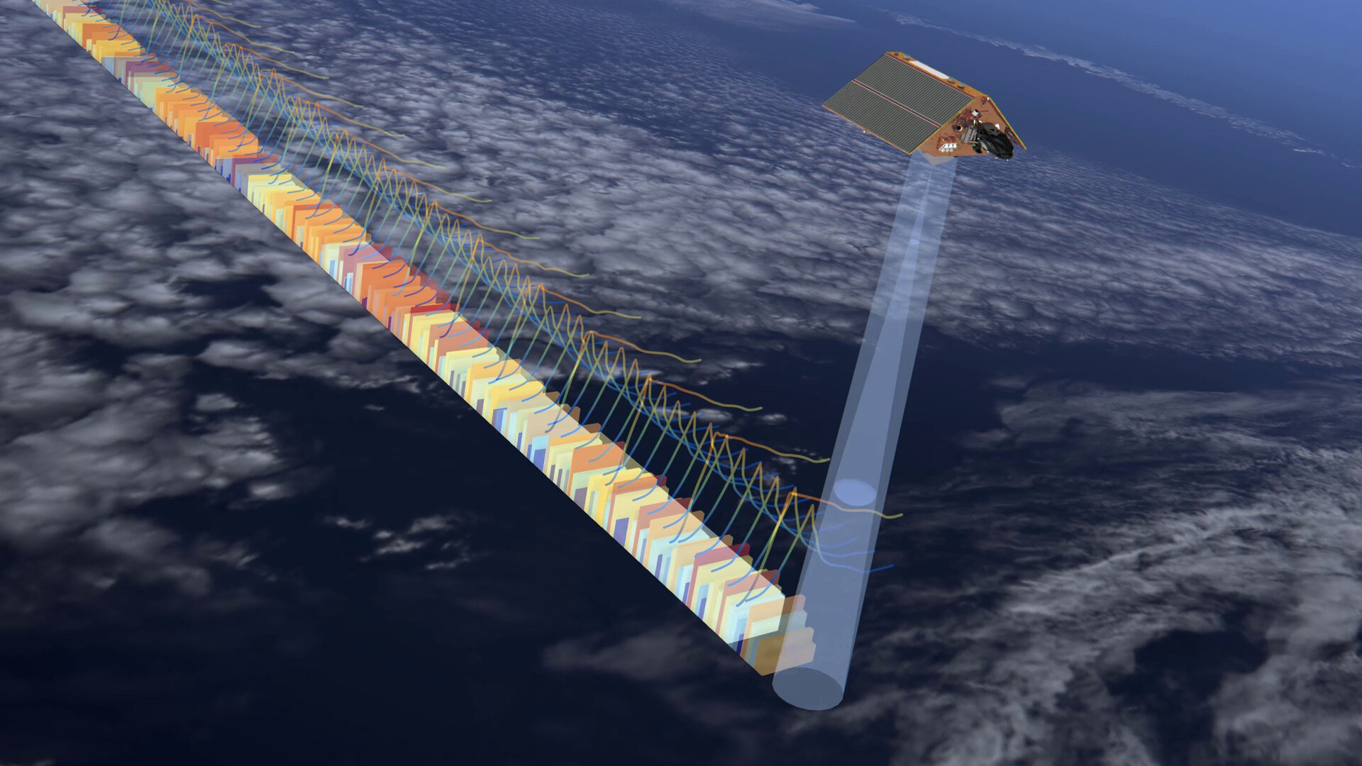 Altimetry Satellite Mission News from the 2026 OSTST meeting in Wiesbaden, GermanyRelease Date: 07/20/2026
The Ocean Surface Topography Science Team (OSTST) meeting held its annual meeting in Wiesbaden, Germany (June 22 – 26, 2026). The first session of the meeting was devoted to summarizing the status for many current and planned altimetry missions. We provide a summary of the mission plans for those missions that include SLR tracking for Precise Orbit Determination (POD) (as well as GNSS and/or DORIS).
SWOT (Surface Water and Ocean Topography Project Status, Sen & Marechal, 2026):
Jason-3: (Jason-3 Project status, Russano et al., 2026):
Copernicus Sentinel-3 Mission Overview & status (Lucas and Di Bella, 2026):
Sentinel-6 Mission Overview (Scharroo et al., 2026)
Overview of Copernicus altimetry constellation for the next 20 years (Cacciari, 2026):
![]() NASA Small Satellite Could Make Global Positioning More PreciseRelease Date: 07/13/2026
NASA Small Satellite Could Make Global Positioning More PreciseRelease Date: 07/13/2026
A NASA satellite the size of a suitcase, which aims to merge different observing systems and lead to more accurate mapping of Earth, launched July 7 from the Vandenberg Space Force Base in California aboard SpaceX’s Transport-17 mission.
This novel CubeSat, known as the Geodetic Reference Instrument Transponder for Small Satellites, or GRITSS, will demonstrate the feasibility of a new technique for connecting three independent observing systems: the Very Long Baseline Interferometry (VLBI) stations, which use radio telescopes; GPS receivers, which use navigation satellites; and Satellite Laser Ranging, which relies on lasers to measure a distance from the ground to a retroreflector in space.
Read the NASA press release.
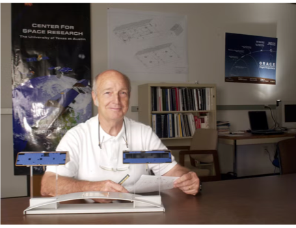 Tribute to Byron TapleyRelease Date: 06/22/2026
The ILRS joins The University of Texas at Austin, the Center for Space Research and the international community to mourn the passing of Professor Byron D. Tapley, who died peacefully at his home in Austin, Texas, on June 22, 2026, at the age of 93.
Professor Tapley was a pioneer of modern space geodesy whose vision and leadership transformed the way scientists observe the Earth from space. Over a career spanning six decades, he advanced satellite geodesy into a cornerstone of Earth system science, making lasting contributions to geodesy, oceanography, hydrology and climate science.
Prof. Tapley joined the faculty at The University of Texas at Austin, Department of Aerospace Engineering and Engineering Mechanics in 1960, and earned the title of Professor in 1968. He served as Department chair from 1966 to 1977. In 1981 he founded the Center for Space Research (CSR), for which he continued to serve as director until 2015. Under his leadership, UT/CSR became a vigorous research institution making important contributions in remote sensing and space mission design. Many current members of the scientific community today in space geodesy are former students, graduates, or research associates of UT/CSR.
Professor Tapley made pioneering contributions to satellite laser ranging, precise orbit determination and radar altimetry. His involvement with altimetry spanned three decades, and included the Seasat, TOPEX/Poseidon and Jason missions, as well as ESA’s ERS-1 & ERS-2 missions. He led the Precise Orbit Determination (POD) team for TOPEX/Poseidon in the years prior to and shortly after the launch of TOPEX in 1992. Under his leadership, the TOPEX POD team successfully demonstrated an RMS radial orbit accuracy for TOPEX of 2.0- 2.5 cm, a revolution in precision orbit determination at the time. Many of the techniques of POD pioneered in the early days of the TOPEX mission, continue to be applied today.
Starting in 1997, Prof. Tapley became Principal Investigator (PI) of the NASA/DLR Gravity Recovery and Climate Experiment (GRACE) mission, with Dr. Christoph Reigber (GFZ, Potsdam) as Co-Principal Investigator. Launched in March 2002, GRACE became the first mission to map globally the time variations in the Earth’s gravity field, producing snapshots of the mass variations in the Earth’s system every 30 days. Designed to operate for five years, the mission operated for 15 years, and transformed how scientists measure and understand gravity and mass change from space. Following the success of GRACE, Professor Tapley remained a tireless advocate for the continuity of satellite gravity observations through the GRACE Follow-On (GRACE-FO) mission (launched in 2018) and the future GRACE-C (scheduled for launch in 2028) and other gravity missions.
The ILRS salutes a giant in space geodesy, and acknowledges Professor Tapley’s contributions to Satellite Laser Ranging (SLR) and the ILRS over many years.
Photo credit: The University of Texas at Austin, Cockrell School of Engineering.
![]() 5-Digit Satellite Catalog Number (aka NORAD ID) will soon become 6-DigitsRelease Date: 06/17/2026
5-Digit Satellite Catalog Number (aka NORAD ID) will soon become 6-DigitsRelease Date: 06/17/2026
The 5-Digit Satellite Catalog Number, formerly known as the NORAD Id, has been projected to run out in July/August 2026. After 69999 has been assigned, any new cataloged objects will have 6-digits. The Legacy Two-Line Element (TLE) Data Format can`t accommodate a 6-digit object. In May 2020, to overcome this constraint Celes Trak has implemented a CSV TLE data format.
Also, in 2020, SpaceTrack.Org started to provide orbital elements in the CCSDS Orbit Mean-Element Message (OMM) format, which can handle 9-digit object numbers. The CCSDS OMMs are available in Extensible Markup Language (XML), JavaScript Object Notation (JSON), and Keyword Value Notation (KVN) format.
Since the ILRS CPF and CRD formats are free format with spaces between entries, no changes to these formats are necessary.
However; stations or other users that have software which converts Legacy Two-Line-Element (TLE) Data into Consolidate Prediction Files (CPFs) will require software modifications to support new 6-digit objects. In addition, stations that have software that assumes the Satellite Catalog Number is a 5-digit integer will require modifications to accommodate the new 6-digit objects.
Any questions and/or concerns can be addressed to the ILRS Central Bureau.
 NASA Laser Reflecting Instrument Makes GPS Satellite More Accurate Release Date: 03/19/2026
A NASA Laser Retroreflector Array (LRA) that will improve Global Positioning System (GPS) accuracy is now operational as of March 9, 2026.
The LRA was launched aboard the GPS III SV-09 satellite, the ninth of the U.S. Space Force’s Block III Global Positioning System satellites, on January 27, 2026. LRA's are sets of mirrors shaped like the corners of a cube, a configuration that is designed to precisely reflect beams of light back to their source. This LRA for GPS II SV-09 was developed by the NASA Space Geodesy Project in partnership with the U.S. Naval Research Laboratory’s Naval Center for Space Technology in Washington D.C. The LRA is a planar array consisting of 48 recessed ~4.09 cm diameter Suprasil cubes.
Stations of the ILRS were provided with predictions (which are now at the ILRS data centers, the NASA CDDIS and the EDC), and have begun routine ranging to this target. The SLR normal points (CRDv2) and full-rate data (CRDv2) to this GPS III SV-09 LRA are available at the ILRS data centers
Read the NASA press release.
Michael Croteau Short Biography
Dr. Michael Croteau is a satellite geodesist at NASA Goddard Space Flight Center. His primary research centers on time-variable gravity field estimation from gravimetry (GRACE and GRACE-FO) and Satellite Laser Ranging. Additionally, he has been involved in studies of Earth’s global mean sea level budget, numerous applications-focused data projects, and NASA’s Open Science initiative. He first joined Goddard in 2019 as a NASA Postdoctoral Fellow and has served as a Research Geophysicist since 2020.![]() ILRS Central Bureau Director transitionRelease Date: 02/19/2026
ILRS Central Bureau Director transitionRelease Date: 02/19/2026
The ILRS would like to announce the transition of the ILRS Central Bureau Director position from Dr. Michael Pearlman to Dr. Michael Croteau, effective February 19th, 2026.
He is also appointed as an ex officio member to the ILRS Governing Board.
We thank Dr. Michael Pearlman for all his many years of service, and very much appreciate his contributions to the organization.
Dr. Pearlman has graciously agreed to continue supporting the ILRS Central Bureau through this transition and we look forward to continuing to benefit from his vast expertise.
Please welcome Michael Croteau (https://science.gsfc.nasa.gov/sci/bio/michael.j.croteau) to the organization.

![]() Passing of Andrew SinclairRelease Date: 02/04/2026
Passing of Andrew SinclairRelease Date: 02/04/2026
It is with great sorrow that the ILRS must report that our colleague Andy Sinclair passed away last week, in the hospital in Edinburgh, UK, following a stroke.
Andy was a prime mover in the 1980s, securing multi-agency funding to develop and operate the UK's laser ranging facility at Herstmonceux and, realizing the potential geodetic value of the emerging technique of Global Positioning System (GPS), he worked with Newcastle University to site the UK's primary GPS receiver next to the SLR site. A celestial mechanic by trade, he was key to the early development of the Satellite Analysis code SATAN, versions of which remain in use today for research and for generation of ITRF products from global SLR measurements.
Andy was a leading force within the laser ranging and wider geodetic community, both in the UK and internationally; he led the EUROLAS consortium prior to the formation of the ILRS and was a strong advocate for the need for accurate laser ranging measurements and for cooperation within the Networks.
He is survived by his wife Janet, with Andy a lifelong member of staff at the Royal Greenwich Observatory both at Herstmonceux and Cambridge until its closure there at the end of 1998, when they took early retirement.
![]() Release of ITRF2020-u2024Release Date: 12/19/2025
Release of ITRF2020-u2024Release Date: 12/19/2025
On September 30, 2025, the ITRS Center at the Institut Géographique National (IGN) released the second update of ITRF2020, ITRF2020-u2024. The updated solution is based on data submitted by the geodetic services, the IDS, the IGS, the ILRS and the IVS from 2021.0 to 2025.0, in addition to the data originally included for ITRF2020. Extensive information is available on the following website, from where the new ITRF2020 solution update can be obtained:
URL: https://itrf.ign.fr/en/solutions/ITRF2020-u2024
 Successful launch of the Sentinel-6B missionRelease Date: 12/02/2025
The Sentinel-6B satellite was successfully launched on November 17, 2025 at 05:21 UTC from Vandenburg Air Force Base in California (USA) using a Falcon 9 Block V rocket. The satellite will follow in the footsteps of the Sentinel-6A Michael Freilich mission, launched in November 2020. The Sentinel-6B becomes the sixth satellite since TOPEX to occupy the same orbit at 1336 km altitude and 66.0 deg inclination, continuing a now 33-yr record of precise sea-surface-height measurements from a 9.91 day repeat orbit.
As the second of two satellites in the mission (Sentinel-6A Michael Freilich, launched in 2020), Sentinel-6B will take over from the current Sentinel-6A satellite as the internationally recognized reference satellite. This means its data will be used to calibrate all other altimetry missions, ensuring the accuracy of all global sea-level measurements. The satellite's instruments include a Poseidon-4 radar altimeter, a microwave radiometer, and a GNSS-Radio Occultation instrument. Tracking is provided by GNSS, DORIS and Satellite Laser Ranging (SLR).
Sentinel-6B will reach its operational orbit by December 16, 2025, where it will initially fly a tandem mission with Sentinel-6A, separated by only 30 seconds along track, in order to calibrate the flight instruments, and to ensure the continuity of the long-term altimetry data record from this orbit. The tandem mission will last for on the order of six months, after which Sentinel-6A will be moved to another orbit, mostly likely an interleaved orbit with Sentinel-6B.
The mission sponsors include ESA, NASA, the CNES, NOAA and EUMETSAT, as well as the European Union Copernicus program.
![]() ILRS Data Files for SLR processing have been updated Release Date: 05/30/2025
The ILRS Analysis Standing Committee (ASC) has released updates to the following files:
ILRS Data Files for SLR processing have been updated Release Date: 05/30/2025
The ILRS Analysis Standing Committee (ASC) has released updates to the following files:
(1) Data Handling File
(2) Eccentricity Files
(3) SLRF2020 Positions & Velocities
These files include the following updates that have been applied since the start of 2025:
(1) Updates to the station positions for Tsukuba (Japan, 7306) and Yebes (7817). Note that the coordinates for Tsukuba (7306, TKBL) include a discontinuity on 2024-01-01 to handle the coseismic displacement due to the Noto earthquake. The new Tsukuba coordinates were obtained from a stacking of normal equations and SLR data from LAGEOS-1, LAGEOS-2, LARES & LARES-2 for 2022-2023 and 2024-2025 (1st quarter).
(2) Addition of the new discontinuities for various stations from ITRF2020-u2023:
• 1890 A01 → A02 at 22:264:00000
• 7105 A01 → A02 at 20:232:00000
• 7396 A01 → A02 at 20:274:00000
• 7501 A02 → A03 at 21:104:00000
• 7835 A02 → A03 at 94:012:00000
• 7841 A01 → A02 at 11:121:00000
(3) Addition of station coordinates for the new OmniSLR station at Ishioka (7317, ISHL).
(4) Addition of provisional (placeholder) coordinates for the anticipated new SLR station at Xian, China (7329, NTSC).
(5) The updated eccentricity files now include values for Ishioka (7317, ISHL) and Xian (7329, NTSC). Note the large “Z” component of the eccentricity vector for Ishioka (7317) of 1.54 m.
(6) The Data Handling File (DHF) now includes range-bias data for LARES-2. In addition range-bias data was updated through the end of 2024.
Please direct any questions to the Mathis Bloßfeld @ Analysis Standing Committee (ASC) and to the ILRS Central Bureau.
![]() Cancellation of ILRS Technical Workshop in Arequipa, Peru Release Date: 05/23/2025
Due to circumstances beyond their control, the University of San Agustin (UNSA) will not be able to host the 2025 International Workshop on Laser Ranging at Arequipa in October 2025. The ILRS thanks the UNSA team for all their efforts planning and preparing for hosting the workshop. The ILRS is considering the option of holding a virtual meeting this year (2025) if there is sufficient interest, support for the organization, and approval by the ILRS Governing Board. The ILRS Central Bureau welcomes your thoughts regarding holding a potential virtual ILRS workshop as well as offers to help organize the meeting along with the Central Bureau. The next in-person ILRS workshop will be in Buenos Aires, Argentina in 2026.
Cancellation of ILRS Technical Workshop in Arequipa, Peru Release Date: 05/23/2025
Due to circumstances beyond their control, the University of San Agustin (UNSA) will not be able to host the 2025 International Workshop on Laser Ranging at Arequipa in October 2025. The ILRS thanks the UNSA team for all their efforts planning and preparing for hosting the workshop. The ILRS is considering the option of holding a virtual meeting this year (2025) if there is sufficient interest, support for the organization, and approval by the ILRS Governing Board. The ILRS Central Bureau welcomes your thoughts regarding holding a potential virtual ILRS workshop as well as offers to help organize the meeting along with the Central Bureau. The next in-person ILRS workshop will be in Buenos Aires, Argentina in 2026.
![]() ILRS Central Bureau surveys stations on the ILRS Tracking Priority ListRelease Date: 04/25/2025
In March 2025, the ILRS Central Bureau (CB) conducted a survey of the ILRS stations to try and understand better how stations used the ILRS Priority List. Currently, the ILRS priority list is constructed to according to satellite orbit parameters as well as according to special project needs. The satellite tracking priority is generally arranged by altitude such that the satellites at the lowest altitude (and thus the shortest satellite passes) have the highest tracking priority. While logical, this mode paradoxically places the geodetic ITRF satellites (i.e. LAGEOS-1, LAGEOS-2, LARES-2) at the apparently high tracking priorities of 24, 25 & 18 respectively. In order to provide information that could inform a redesign of how tracking priorities are presented and communicated to the stations, the ILRS CB asked a series of short questions in a short survey. The survey was designed to be anonymous and left the possibility for survey participants to provide more information and other comments.
ILRS Central Bureau surveys stations on the ILRS Tracking Priority ListRelease Date: 04/25/2025
In March 2025, the ILRS Central Bureau (CB) conducted a survey of the ILRS stations to try and understand better how stations used the ILRS Priority List. Currently, the ILRS priority list is constructed to according to satellite orbit parameters as well as according to special project needs. The satellite tracking priority is generally arranged by altitude such that the satellites at the lowest altitude (and thus the shortest satellite passes) have the highest tracking priority. While logical, this mode paradoxically places the geodetic ITRF satellites (i.e. LAGEOS-1, LAGEOS-2, LARES-2) at the apparently high tracking priorities of 24, 25 & 18 respectively. In order to provide information that could inform a redesign of how tracking priorities are presented and communicated to the stations, the ILRS CB asked a series of short questions in a short survey. The survey was designed to be anonymous and left the possibility for survey participants to provide more information and other comments.
The ILRS station tracking priority survey results can be found here.
 ILRS Governing Board Approves Resumption of Tracking for the Westpac Satellite Release Date: 03/20/2025
The ILRS Governing Board has approved resuming tracking of the WESTPAC mission, originally launched on July 10, 1998, and tracked by the ILRS from 1998 to 2002. The GB believes there is scientific justification for readmitting WESTPAC to the ILRS target list because routine SLR measurements could complement the data from the existing geodetic targets, particularly for gravity field recovery, and could also provide atmospheric and range error information.
ILRS Governing Board Approves Resumption of Tracking for the Westpac Satellite Release Date: 03/20/2025
The ILRS Governing Board has approved resuming tracking of the WESTPAC mission, originally launched on July 10, 1998, and tracked by the ILRS from 1998 to 2002. The GB believes there is scientific justification for readmitting WESTPAC to the ILRS target list because routine SLR measurements could complement the data from the existing geodetic targets, particularly for gravity field recovery, and could also provide atmospheric and range error information.
The decommissioned geodetic satellite WESTPAC will be returned to the ILRS target list with a low priority, not resulting in a significant burden to station scheduling or impact on other priority targets. In tests led by the ILRS Network and Engineering Standing Committeee (NESC), ILRS stations have demonstrated that with good predictions Westpac can be tracked routinely during the day and night, without a significant impact on the station tracking schedules or at the expense of other ILRS targets.
CPF predictions have improved significantly since they became available and the time bias for the latest daily prediction can be expected to be as low as only a few milliseconds. This is very advantageous during daylight tracking and gives observers confidence to not search widely in along-track corrections, but to instead wait for a retro-reflector to be visible. Daily predictions are currently provided by the Space Geodesy Facility, Herstmonceux and are available for download at the ILRS Data Centers.
All CRD2 data and ancillary data (CPFs) must use the new designations for the NORAD number (25398) and COSPAR ID (1998-043E, 9804305) or else the data will be rejected by the Automatic Quality Control checks at the EDC and/or at the NASA SLR Data Operations Center.
![]() The ILRS Monthly Report Cards and Monthly Station Performance Assessment Maps have been updated Release Date: 03/14/2025
The ILRS Monthly Report Cards and Monthly Station Performance Assessment Maps have been updated to include LARES-2 in the geodetic satellite group (LAGEOS-1, LAGEOS-2, LARES). This change was made starting with the January 2025 release.
The ILRS Monthly Report Cards and Monthly Station Performance Assessment Maps have been updated Release Date: 03/14/2025
The ILRS Monthly Report Cards and Monthly Station Performance Assessment Maps have been updated to include LARES-2 in the geodetic satellite group (LAGEOS-1, LAGEOS-2, LARES). This change was made starting with the January 2025 release.
The ILRS Monthly Report Cards can be viewed at the following links:
- Monthly Report Cards:
https://ilrs.gsfc.nasa.gov/network/system_performance/global_report_cards/monthly/index.html - Monthly Station Performance Assessment Maps:
https://ilrs.gsfc.nasa.gov/network/system_performance/monthly_station_performance_maps/index.html
 Passing of Dr. Jorge del Pino - University of Latvia, Riga Station Release Date: 01/22/2025
It is with great sadness that we relay to the ILRS community a message from Kalvis Salmins and Ludwig Grunwaldt, informing us of the passing of our ILRS colleague Dr. Jorge del Pino.
Passing of Dr. Jorge del Pino - University of Latvia, Riga Station Release Date: 01/22/2025
It is with great sadness that we relay to the ILRS community a message from Kalvis Salmins and Ludwig Grunwaldt, informing us of the passing of our ILRS colleague Dr. Jorge del Pino.
Our colleague and friend Dr. Jorge del Pino, a long-term member of laser ranging community, passed away on Friday, January 17, 2025.
Born 1949 in Havana, his lifelong career in satellite observations started in the 1970s at the satellite tracking station Santiago de Cuba which operated a 1st generation laser system starting in 1977. In 1985, he defended his PhD thesis dedicated to the efficient second-harmonic generation for laser ranging at the Czech Technical University in Prague.
Jorge del Pino became the Cuban manager of the Intercosmos project of a 2nd generation SLR system which was operated between 1985 and 1998 in cooperation between ZIPE/GFZ Potsdam and CENAIS in Santiago de Cuba. He also contributed major parts of the real-time tracking software for the 3rd generation SLR systems in Potsdam.
Since 2013, he worked at Institute of Astronomy University of Latvia. Dr. Jorge del Pino contributed to the renewal of the SLR station Riga and to improving its performance. He participated in the station operations until the last days of his life. We will miss him greatly.
On behalf of the ILRS, our sincere condolences to his loved ones.

 Passing of Dr. Henry Herman Plotkin - May 6, 1927 – January 9, 2025 Release Date: 01/10/2025
It is with great sadness that we announce the passing of Dr. Henry H. Plotkin on January 9th, 2025. Dr. Plotkin had a distinguished long career as a researcher, manager, and senior executive with NASA Goddard Space Flight Center. He pioneered the development of satellite laser ranging and communication, leading to the first successful satellite laser ranging experiment at Goddard Space Flight Center (GSFC) in 1964, and the development and flight of optical instruments and sensors for space science and earth observation. He was the initiator and manager of Center and Agency programs to expand spacecraft, Space Station, and science instrument capabilities through use of new technologies. As the lead of the NASA GSFC Optical Systems Branch from 1960 to 1967, he pioneered development of lasers and optical systems for ultra-precise space tracking and high-rate optical communications. He proposed and developed the first series of reflecting geodetic satellites and initiated the international network of laser stations for gravity studies and crustal dynamics. He was a member of original team for the Apollo Lunar Laser Reflectors that were placed on the moon during the Apollo 11, 14, and 15 missions. He managed space technology programs in precision atomic frequency standards, information processing and data storage, microwave and radio communications and tracking.
Passing of Dr. Henry Herman Plotkin - May 6, 1927 – January 9, 2025 Release Date: 01/10/2025
It is with great sadness that we announce the passing of Dr. Henry H. Plotkin on January 9th, 2025. Dr. Plotkin had a distinguished long career as a researcher, manager, and senior executive with NASA Goddard Space Flight Center. He pioneered the development of satellite laser ranging and communication, leading to the first successful satellite laser ranging experiment at Goddard Space Flight Center (GSFC) in 1964, and the development and flight of optical instruments and sensors for space science and earth observation. He was the initiator and manager of Center and Agency programs to expand spacecraft, Space Station, and science instrument capabilities through use of new technologies. As the lead of the NASA GSFC Optical Systems Branch from 1960 to 1967, he pioneered development of lasers and optical systems for ultra-precise space tracking and high-rate optical communications. He proposed and developed the first series of reflecting geodetic satellites and initiated the international network of laser stations for gravity studies and crustal dynamics. He was a member of original team for the Apollo Lunar Laser Reflectors that were placed on the moon during the Apollo 11, 14, and 15 missions. He managed space technology programs in precision atomic frequency standards, information processing and data storage, microwave and radio communications and tracking.
Dr. Plotkin was a very special member of the International Laser Ranging community. In 1973, he was one of the organizers of the first International Laser Ranging Workshop in Lagonissi, Greece, hosted by a long-term Space Geodesy colleague Professor George Veis from the National Technical University in Athens. At University of Maryland Baltimore County (UMBC), Dr. Plotkin collaborated in research, teaching, and program administration in the Joint Center for Earth Systems Technology (JCET). He prepared the successful proposal for the Goddard Earth Sciences and Technology Center and served as Associate Director and Chief Scientist. He served as the Associate Administrator of the new Center for Advanced Studies in Photonics Research.
His achievements were recognized through personal awards such as NASA Goddard John C. Lindsay Award, the NASA Medal for Exceptional Scientific Achievement, the Goddard Award of Merit, and the special award from the ILRS: Satellite Laser Ranging Pioneer.
Dr. Plotkin's Obituary
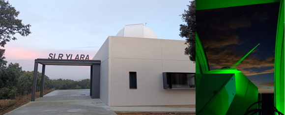
![]() Yebes (YEBL-7817) Station, Spain, joins the ILRS Network Release Date: 10/16/2024
The ILRS Analysis Standing Committee, has successfully completed the qualification for operational status for the Yebes SLR station (7817) in the ILRS network. The system demonstrates a 2.1 to 2.7 mm Normal Point (NP) precision on the two LAGEOS and LARES-2 targets, and about 5.6 mm on LARES. The QC results show negligible biases to within the statistical uncertainty of the analyses. The present analyses were conducted with the laser ranging data at 1064 nm, and the default values for the satellite CoM offsets. Performance at 532 nm will continue to be monitored. All of the quarantined data has been placed in the public domain.
Yebes (YEBL-7817) Station, Spain, joins the ILRS Network Release Date: 10/16/2024
The ILRS Analysis Standing Committee, has successfully completed the qualification for operational status for the Yebes SLR station (7817) in the ILRS network. The system demonstrates a 2.1 to 2.7 mm Normal Point (NP) precision on the two LAGEOS and LARES-2 targets, and about 5.6 mm on LARES. The QC results show negligible biases to within the statistical uncertainty of the analyses. The present analyses were conducted with the laser ranging data at 1064 nm, and the default values for the satellite CoM offsets. Performance at 532 nm will continue to be monitored. All of the quarantined data has been placed in the public domain.
We welcome the station to the network!
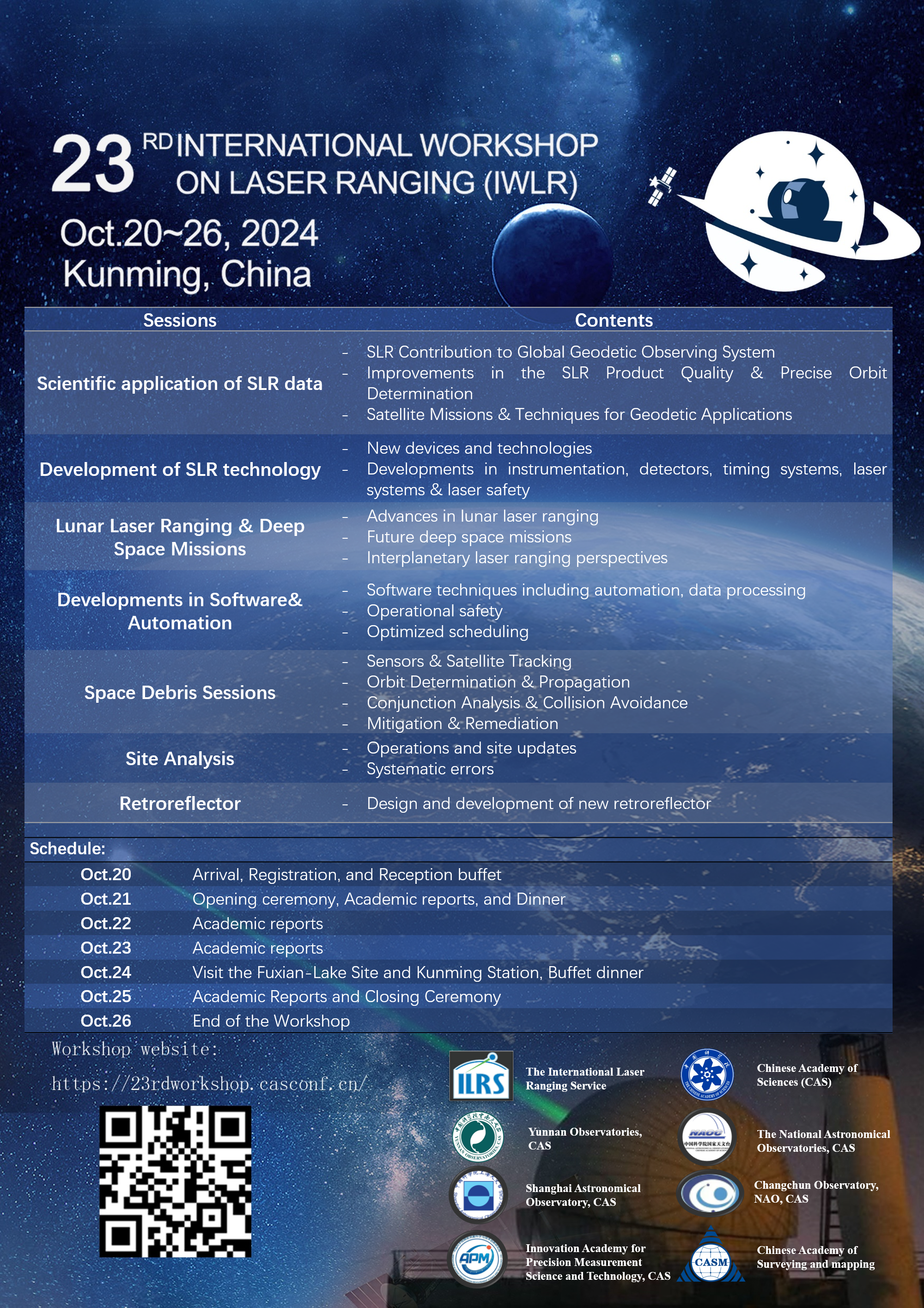
 The 23rd International Workshop on Laser Ranging, Kunming - China, Oct.20th–26th, 2024 – Updates to Important Deadlines Release Date: 09/12/2024
The Yunnan Observatories and the International Laser Ranging Service (ILRS) have released an update to Important Deadlines for the 23rd International Workshop on Laser Ranging in Kunming, China.
The 23rd International Workshop on Laser Ranging, Kunming - China, Oct.20th–26th, 2024 – Updates to Important Deadlines Release Date: 09/12/2024
The Yunnan Observatories and the International Laser Ranging Service (ILRS) have released an update to Important Deadlines for the 23rd International Workshop on Laser Ranging in Kunming, China.
Abstract Submission: Now due by October 7, 2024.
Hotel Reservations: Book by October 11, 2024 at the latest.
The submission and reservation can be accessed through the workshop website:
https://23rdworkshop.casconf.cn/
Please adjust your plans accordingly.
We look forward to your participation, in person or virtually.
 GGOS releases short film highlighting the Terrestrial Reference Frame Release Date: 06/20/2024

The GGOS (Global Geodetic Observing System) Coordinating Office has now released a new 2.5-minute short film highlighting the critical role of geodetic terrestrial reference frames. This video is primarily aimed at the general public and has been produced in collaboration with the UN-GGCE (United Nations Global Geodetic Center of Excellence). The video is available with subtitles in over 16 languages and can be viewed on the GGOS YouTube channel:
https://www.youtube.com/watch?v=zfqq-0d2txk
This short video complements the more comprehensive 10-minute version ( https://www.youtube.com/watch?v=vvNXv05646M), available in multiple languages, which has been viewed over 40,000 times since its release in September 2023.
On behalf of GGOS, the ILRS kindly invites ILRS community members to share this video with colleagues in their institutes, universities and the general public.
Please send comments or feedback concerning these videos to the ILRS central bureau or to Martin Sehnal at the GGOS Coordinating Office (Federal Office of Metrology and Surveying, BEV, Austria).
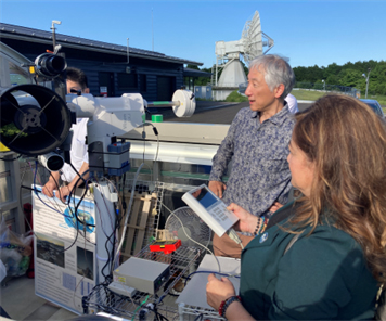
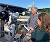 ILRS Visits the Japan Aerospace Exploration Agency (JAXA), the Geospatial Information Authority of Japan (GIS) and the Tsukuba and Ishioka Satellite Laser Ranging Stations, following participation in the Japan Geosciences Union Meeting 2024, in Chiba, Japan. Release Date: 06/10/2024
The ILRS Central Bureau Secretary, Claudia C. Carabajal, and Dr. Jean-Paul Boy from the University of Strasbourg, France were hosted by our Japanese colleagues for a visit to the Japan Aerospace Exploration Agency (JAXA), the Geospatial Information Authority of Japan (GIS) and the SLR stations at Tsukuba and Ishioka. The visit was organized by Dr. Toshimichi Otsubo. The Omni-SLR system is being tested at the Ishioka Station.
ILRS Visits the Japan Aerospace Exploration Agency (JAXA), the Geospatial Information Authority of Japan (GIS) and the Tsukuba and Ishioka Satellite Laser Ranging Stations, following participation in the Japan Geosciences Union Meeting 2024, in Chiba, Japan. Release Date: 06/10/2024
The ILRS Central Bureau Secretary, Claudia C. Carabajal, and Dr. Jean-Paul Boy from the University of Strasbourg, France were hosted by our Japanese colleagues for a visit to the Japan Aerospace Exploration Agency (JAXA), the Geospatial Information Authority of Japan (GIS) and the SLR stations at Tsukuba and Ishioka. The visit was organized by Dr. Toshimichi Otsubo. The Omni-SLR system is being tested at the Ishioka Station.
More pictures of the visit can be found here.
![]() National Geodetic Survey (NGS) 2024 Local Tie Survey for Greenbelt is now availableRelease Date: 06/06/2024
The National Geodetic Survey (NGS) has posted the results of their recent local tie survey at the Goddard Geophysical and Astronomical Observatory (GGAO) in Greenbelt, Maryland, U.S.A. The GGAO hosts all four space geodetic techniques, including SLR, VLBI, GNSS & DORIS. The local tie survey took place from March 25 to April 5, 2024, and the NGS team was led by Kevin Jordan of the NGS Field Operations Branch.
National Geodetic Survey (NGS) 2024 Local Tie Survey for Greenbelt is now availableRelease Date: 06/06/2024
The National Geodetic Survey (NGS) has posted the results of their recent local tie survey at the Goddard Geophysical and Astronomical Observatory (GGAO) in Greenbelt, Maryland, U.S.A. The GGAO hosts all four space geodetic techniques, including SLR, VLBI, GNSS & DORIS. The local tie survey took place from March 25 to April 5, 2024, and the NGS team was led by Kevin Jordan of the NGS Field Operations Branch.
The survey results, report, and SINEX file are available at the NOAA/NGS website in the Table by clicking on the links for "Washington (2024)". Please contact the National Geodetic Survey (NGS) and/or the ILRS Central Bureau with any questions or feedback.
URL: https://www.ngs.noaa.gov/corbin/iss/index.shtml
The 23rd International Workshop on Laser Ranging, Kunming - China, Oct.20th–26th, 2024 – Second Announcement Release Date: 05/22/2024
The Yunnan Observatories and the International Laser Ranging Service (ILRS) have released the Second Announcement for the 23rd International Workshop on Laser Ranging in Kunming, China.
The announcement can be found here.
The poster for the Workshop can also be accessed here.
![]() New SLR Analysis Center: CNES, France Release Date: 04/03/2024
The ILRS welcomes the new Centre National d'Etudes Spatiales (CNES) Satellite Laser Ranging (SLR) Analysis Center.
New SLR Analysis Center: CNES, France Release Date: 04/03/2024
The ILRS welcomes the new Centre National d'Etudes Spatiales (CNES) Satellite Laser Ranging (SLR) Analysis Center.
CNES has been successfully validated as ILRS Analysis Centers. The validation was performed by the ASI Combination Center for all the routine ILRS standard products (thanks to Antonio Basoni).
As stated by the ILRS terms of Reference: “The ACs provide, at a minimum, daily-resolution Earth orientation parameters, weekly-averaged station coordinates and satellite orbits, on a daily basis, as well as other products, required by the IERS.”
The contact points are:
Dr. Franck Reinquin Franck.Reinquin@cnes.fr
Dr. Adrian Baños-Garcia abanos-garcia@groupcls.com
 The 23rd International Workshop on Laser Ranging, Kunming - China, Oct.20th–26th, 2024 Release Date: 03/11/2024
The Yunnan Observatories and the International Laser Ranging Service (ILRS) are pleased to announce that the 23rd International Workshop on Laser Ranging will be held in Kunming, China during 20-26 October 2024.
The 23rd International Workshop on Laser Ranging, Kunming - China, Oct.20th–26th, 2024 Release Date: 03/11/2024
The Yunnan Observatories and the International Laser Ranging Service (ILRS) are pleased to announce that the 23rd International Workshop on Laser Ranging will be held in Kunming, China during 20-26 October 2024.

More details can be found in the workshop website online with the link below:
https://23rdworkshop.casconf.cn/
We look forward to your participation!
 Passing of Spanish Navy Observatory researcher Dr. Manuel Catalán Morollón Release Date: 01/12/2024
We are sad to report that Spanish Navy Observatory researcher Dr. Manuel Catalán Morollón passed away on December 12 after a bout with cancer. Dr. Morollón, as leader of the San Fernando SLR Station, spearheaded the recent modernization of the SLR system to improve performance. He was a very active researcher in several Earth Science disciplines; he was dedicated to his work and remained active right up until the end. He was a strong supporter of ILRS and a good friend. He will be greatly missed.
Passing of Spanish Navy Observatory researcher Dr. Manuel Catalán Morollón Release Date: 01/12/2024
We are sad to report that Spanish Navy Observatory researcher Dr. Manuel Catalán Morollón passed away on December 12 after a bout with cancer. Dr. Morollón, as leader of the San Fernando SLR Station, spearheaded the recent modernization of the SLR system to improve performance. He was a very active researcher in several Earth Science disciplines; he was dedicated to his work and remained active right up until the end. He was a strong supporter of ILRS and a good friend. He will be greatly missed.

