Scientific Research Through Laser Ranging
The ILRS supports scientific research and data analysis using Satellite and Lunar Laser Ranging data and their products. The aim of these activities is primarily focused on geodetic and geophysical parameter estimation and geophysical model development. Furthermore, the main thrust of these activities addresses the needs of IERS with products that contribute to the development of an ever more accurate International Terrestrial Reference Frame (ITRF). The unique ability of ILRS to sense the Earth System center of mass with high accuracy, makes these products invaluable in the development of the ITRF, the prime product is the Global Geodetic Observing System (GGOS). The ILRS data and products are collected and generated under strict standards and they contribute to a wide range of scientific, engineering, and operational applications and experimentation.
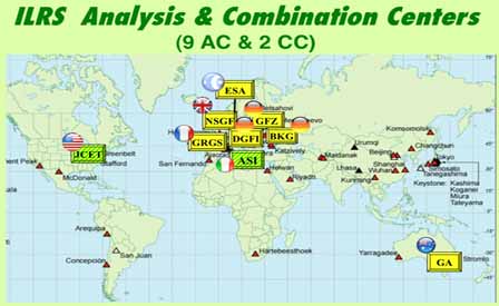
In addition to collecting, merging, archiving and distributing Satellite Laser Ranging (SLR) and Lunar Laser Ranging (LLR) the ILRS interacts with the other IAG (Int. Assoc. of Geodesy) services under the GGOS umbrella, to harmonize the standards and conventions used for its operations and its data analysis and product generation activities. These activities are coordinated, supervised and validated by the Analysis Working Group, with the support of all Analysis Centers and Associate Analysis Centers. The official products of the ILRS are produced by the Combination Centers (primary and back-up) to ensure a unique product for the users with the highest accuracy and fully validated prior to its release. The service encourages international collaboration and strives to include as many different groups from various countries as possible, with a similar variety in the utilized software.
Recent News
(1) Data Handling File
(2) Eccentricity Files
(3) SLRF2020 Positions & Velocities
Read more
The ILRS station tracking priority survey results can be found here.
Read more...


