
HY-2
Jump to: Mission Objectives, Mission Instrumentation, Mission Parameters, Additional Information
Mission Photos:
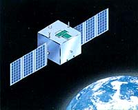
Courtesy of AVISO
Mission Objectives:
The HY-2 satellite is an oceanographic remote sensing satellite series developed by China's National Satellite Ocean Application Service (NSOAS); four satellites are planned: HY-2A (2011), HY-2B (2018), HY-2C (TBD), HY-2D (TBD). The objective of HY-2 is to monitor the dynamic ocean environment with radar sensors to measure sea surface wind field, sea surface height and sea surface temperature. It will include a dual-frequency radar altimeter in Ku and C-bands, a Ku-band rotating scatterometer and microwave imager. The orbit is sun-synchronous: the first 2 years with a 14-day cycle, then one year with geodetic orbit (168-day cycle, 5-day approx. subcycle).
Mission Instrumentation:
HY-2A will have the following instrumentation onboard:
- Micro-Wave Radiometer
- DORIS
- Retroreflector Array
- Ku-band Rotating Pencil-beam Scatterometer
- Ku- and C-band Pulsed-Limited Nadir Radar Altimeter
- GPS
Mission Parameters:
| HY-2A | HY-2B | HY-2C | HY-2D | |
| Sponsor: | NSOAS | NSOAS | NSOAS | NSOAS |
| Expected Life: | 3 years | 3 years | 5 years | 3 years |
| Primary Applications: | Oceanography | Oceanography | Oceanography | Oceanography |
| COSPAR ID: | 1104301 | 1808101 | 2006601 | 2104301 |
| SIC Code: | 2201 | 2208 | 2209 | 2211 |
| Satellite Catalog (NORAD) Number: | 37781 | 43655 | 46469 | 48621 |
| Launch Date: | 16-Aug-2011 | 25-Oct-2018 | 21-Sep-2020 | 30-May-2021 |
| RRA Size: | ||||
| RRA Shape: | hemisphere | hemisphere | hemisphere | hemisphere |
| Reflectors: | 9 corner cubes | 9 corner cubes | 9 corner cubes | 9 corner cubes |
| Size of Reflector: | 16.5 mm | 16.5 mm | 33 mm diameter 26.2 mm height |
16.5 mm |
| Orbit: | circular | circular | circular | circular |
| Inclination: | 99.35 degrees | 99.35 degrees | 66 degrees | 66 degrees |
| Altitude: | 971 km | 971 km | 957 km | 971 km |
| Eccentricity: | 0.00117 | 0.00117 | 0.000012 | 0.00117 |
Additional Information:
Web sites:
- AVISO HY-2 page
- NSOAS home page
