
ALOS
Jump to: Mission Objectives, Mission Instrumentation, Mission Parameters, Additional Information
Mission Photos:
 |
 |
| Courtesy of JAXA | |
Mission Objectives:
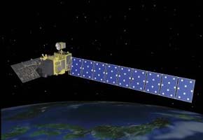
The Advanced Land Observing Satellite (ALOS) will perform high-resolution observation of the earth's surface to assist in the process of compiling very detailed maps of the Pacific rim region. ALOS will also be used to monitor disasters for environmental protection and for maintaining and developing earth observation technology. ALOS launched on January 24, 2006.
Mission Instrumentation:
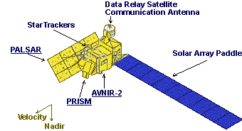
ALOS has the following instrumentation onboard:
- Panchromatic Remote-sensing Instrument for Stereo Mapping (PRISM)
- Advanced Visible Near-Infrared Radiometer-2 (AVNIR-2)
- Phased Array L-band Synthetic Aperture Radar (PALSAR)
- Data control system
- Retroreflector array
Mission Parameters:
| Sponsor: | JAXA |
| Expected Life: | 3 years |
| Primary Applications: | Mapping and environmental monitoring |
| Primary SLR Applications: | Precision orbit determination |
| COSPAR ID: | 0600201 |
| SIC Code: | 1557 |
| Satellite Catalog (NORAD) Number: | 28931 |
| Launch Date: | January 24, 2006 |
| RRA Diameter: | 20 cm |
| RRA Shape: | Hemisphere |
| Reflectors: | 9 |
| Orbit: | Circular, sun-synchronous sub-recurrent |
| Inclination: | 98 degrees |
| Eccentricity: | 0.001 |
| Perigee: | 720 km |
| Period: | 99 minutes |
| Weight: | 3,750 kg |
