
SEASAT
Jump to: Mission Objectives, Mission Instrumentation, Mission Parameters, Additional Information
Mission Photos:
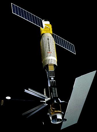
Courtesy of NASA GSFC
Mission Objectives:
Seasat was the first satellite designed for remote sensing of the Earth's oceans with a variety of microwave instruments, including an ocean radar altimeter for measuring sea surface height, a scatterometer for measuring surface winds, a Visible/Infrared Radiometer, and a synthetic aperture (imaging) radar. In addition to studying the oceans, the SAR instrument also obtained spectacular data over land areas, however SAR data were returned only when the s/c was in range of a handful of ground stations. The mission was designed to demonstrate the feasibility of global satellite monitoring of oceanographic phenomena and to help determine the requirements for an operational ocean remote sensing satellite system. Specific objectives were to collect data on sea-surface winds, sea-surface temperatures, wave heights, internal waves, atmospheric water, sea ice features and ocean topography. The mission ended on 10 October 1978 due to a failure of the vehicle's electric power system. Although the spacecraft was operational for only just over three months, the mission demonstrated the feasiblity of using microwave sensors to monitor ocean conditions, and laid the groundwork for future missions to monitor the worlds oceans and cryosphere.
The spacecraft was mounted on the Agena launch module, from which it was not detached after orbit insertion. The spacecraft had dimensions of 21 m in height, with a quasi-cylindrical bus that had a diameter of 1.5 m. The SAR antenna had dimensions of 2.1 x 10.7 m, and the two solar arrays had a surface area of 14.5 m**2. Attitude control for the spacecraft was provided by a combination of momentum wheels, magnetic torquers, and passive gravity gradient stabilization. The spacecraft included a ring-retroreflector array (such as on TOPEX/Poseidon and GEOS-3) for laser ranging. In addition the spacecraft carried a dual-frequency Doppler beacon for tracking by the Tranet network, and was also tracked at S-Band by Unified S-Band ground stations. The laser and Doppler tracking data to SEASAT were used to compute precise orbits for the spacecraft, to enable the generation of science products. The tracking data (laser, Doppler, S-Band) were used in gravity models at NASA GSFC from PGS-S1, PGS-S2, GEM-T2, GEM-T3, JGM-1, JGM-2, to EGM96.
The SAR data from SEASAT were re-released by the University of Alaska satellite Facility in 2013. (URL: https://www.asf.alaska.edu/seasat/)
The nominal flight attitude of the spacecraft is as follows:
Z: Towards the Earth's centerY: Parallel to the negative of the orbit normal vector.
X: In the inertial flight direction (obtained from Y x Z)
More information about attitude determination on SEASAT is obtained from the following publication:
Seasat Final Report
Volume IV: Attitude Determination
by Alfred J. Treder,
JPL Publication 80-30, Volume IV, July 1, 1980
Jet Propulsion Laboratory, Pasadena, CA
(NASA-CR-163943)
(URL: https://ntrs.nasa.gov/search.jsp?R=19800021326)
Mission Instrumentation:
Seasat had the following instrumentation onboard:
- Radar altimeter
- Scatterometer system
- Synthetic aperture radar
- Visible and infrared radiometer
- Scanning multi-channel microwave radiometer
- Retroreflector array
Mission Parameters:
| Sponsor: | NASA |
| Expected Life: | 1-3 years (stop functioning on 10 October 1978) |
| Primary Applications: | ocean topography |
| Primary SLR Applications: | calibrate radar altimeter |
| COSPAR ID: | 7806401 |
| SIC Code: | |
| NORAD SSC Code: | 10967 |
| Launch Date: | June 28, 1978 |
| RRA Diameter: | |
| RRA Shape: | |
| Reflectors: | |
| Orbit: | near-circular |
| Inclination: | 108 degrees |
| Eccentricity: | 0.001 |
| Perigee: | (Oct 5, 1978): 775 km |
| Apogee | (Oct 5, 1978): 790 km |
| Period: | 100 minutes |
| Weight: | 2290 kg |
Additional Information:
Web sites:
- JPL Missions Web site
- JPL Mission and Spacecraft Library
- GSFC
- Lamont-Doherty Earth Observatory, a division of the Columbia Earth Institute at Columbia University
Publications:
- Born, G.H., Richards, M.A. and Rosborough, G.W., "An Empirical Determination of the Effects of Sea State Bias on SEASAT Altimetry", J. Geophys. Res., Vol. 87, pp. 3221-3226, 1982.
- Brenner, A.C., Frey, H. and Zwally, H.J., "Comparisons between Geosat and Seasat tracking over non-ocean surfaces", Geophys. Res. Let., 1990.
- Brown, R.D., Kahn, W.D., McAdoo, D.C. and Himwich, W.E., "Roughness of the Marine Geoid from SEASAT Altimetry", J. Geophys. Res., 88, pp. 1531-1540, 1983.
- Cheney, R.E., "Comparison Data fro SEASAT Altimetry in the Western North Atlantic", J. Geophys. Res., 87, pp. 3247-3253, 1982.
- Cheney, R.E., Marsh, J.G. and Beckley, B.D., "Global Mesoscale Variability from Collinear Tracks of SEASAT Altimeter Data", J. Geophys. Res, Vol. 88, pp. 4343-4354, 1983.
- Colquitt, E.S., Malyevac, C.W. and Anderle, R.J., "Doppler Computed SEASAT Orbits, SEASAT Ephemeris", J. Astr. Sci., Vol. 28, pp. 391-403, 1980.
- De Mey, P., and Menard, Y., "Synoptic eddy fields and dynamical adjustment of GEOS3 and SEASAT altimeter eddyfields in the Northwest Atlantic", J. Geophys. Res., 94, pp. 6221-6231, 1989.
- Diamante, J.M., Douglas, B.C., Porter, D.L., and Masterson, R.P., "Tidal and Geodetic Observations for the SEASAT Altimeter Calibration Experiment", J. Geophys. Res., 87, pp. 3199-3206, 1982.
- Engelis, T., and Knudsen, P., "Orbit improvement and determination of the ocean geoid and topography from seventeen days of SEASAT data", Manuscripta Geodaetica, 14, 2, 1989.
- Engelis, T.L., "Analysis of Sea Surface Topography Using SEASAT Altimeter Data", OSU-Rpt. 343, 97pp, 1983.
- Engelis, T.L., "Global Circulation from SEASAT Altimeter Data", Mar. Geod., V.9, pp. 45-69, 1985.
- Engelis, T.L., and Marsh, J.G., "Sea Surface Topography Determination and Improvement of the Gravity Field Using SEASAT Altimeter Data", presentation to Spring AGU Meeting, Baltimore, 1989.
- Engelis, T.L., and Rapp, R.H., "Global Ocean Circulation Patterns Based on SEASAT Altimeter Data and GEML2 Gravity Field", -reprint from Mar. Geophys. Res., V.7, pp. 55-67, 1984.
- Frey, H., and Brenner, A.C., "Australian Topography from Seasat Overland Altimetry", Geosphys. Res. Let., 17, no. 10, 1990.
- Goad, C.C., Douglas, B.C., and Agreen, R.W., "On the use of Satellite Altimeter Data for Radial Ephemeris Improvement", SEASAT Ephemeris- J. Astr. Sci., V. 28, pp. 419-428, 1980.
- Haines, B. J., Born, G. H., Williamson, R. G., Koblinsky, C. J. (1994), Application of the GEM-T2 gravity field to altimetric satellite orbit computation, J. Geophys. Res., 99(C8), 16237–16254, doi: http://dx.doi.org/10.1029/94JC00257.
- Haxby, W.F., and Weissel, J.K., "Evidence for Small-Scale Mantle Convection From SEASAT Altimeter Data", J. Geophys. Res., 91, pp. 3507-3520, 1986.
- Hayne, G.S., and Hancock, D.W., "Sea-State-Related Altitude Errors in the SEASAT Radar Altimeter", J. Geophys. Res., 87, pp. 3227-3231, 1982.
- Knudsen, P., and Brovelli, M., "Co-Linear and Cross-Over Adjustment of GEOSAT ERM and SEASAT Altimeter Data in the Mediterranean Sea", -copy of a presentation made at the EGS Meeting, Wiesbaden, 1991.
- Lelgemann, D., "Projection, Theoretical Studies and Proposed Execution of the SEASAT-A Altimetry Validation Experiment for SURGE", The Use of Artificial Satellites for Geodesy and Geodynamics, pp. 600-622, 1979.
- Lerch, F.J., Marsh, J.G., Klosko, S.M., and Williamson, R.G., "Gravity Model Improvement for SEASAT", J. Geophys. Res., 87, C5, 3281-3296, 1982.
- Lorell, J., Colquitt, E., and Anderle, R.J., "Ionospheric Correction for SEASAT Altimeter Height Measurement", J. Geophys. Res., 87, pp. 3207-3212, 1982.
- Marsh, J.G., A.C. Brenner, B.D. Beckley, T.V. Martin, "Global Mean Sea Surface Based Upon the Seasat Altimeter Data", J. Geophys. Res., 91, C3, 3501-3506, 1986.
- Marsh, J.G., Koblinsky, C.J., Lerch, F., Klosko, S.M., Robbins, J.W., Williamson, R.G., and Patel, G.B., "Dynamic Sea Surface Topography, Gravity, and Improved Orbit Accuracies from the Direct Evaluation of SEASAT Altimeter Data", J. Geophys. Res, V.95, pp. 13129-13150, 1990.
- Marsh, J.G., Koblinsky, C.J., Zwally, H.J., Brenner, A.C., and Beckley, B.D., "A Global Mean Sea Surface Based Upon GEOS-3 and SEASAT Altimeter Data", J. Geophys. Res., in press, 1992.
- Marsh, J.G., Lerch, F.J., Koblinsky, C.J., Klosko, S.M., and 3 others, "Dynamic Sea Surface Topography, Gravity, and Improved Orbit Accuracies from the Direct Evaluation of SEASAT Altimeter Data", - NASA Tech. Memo. 100735, 99pp, 1989.
- Marsh, J.G., and Williamson, R.G., "Precision Orbit Analyses in Support of the SEASAT Altimeter Experiment", SEASAT Ephemeris,- J. Astr. Sci., V. 28, pp. 345-369, 1980.
- Marsh, J.G., and Williamson, R.G., "SEASAT Altimeter Timing Bias Estimation", J. Geophys. Res., 87, pp. 3232-3238, 1982.
- Mazzega, P., and Houry, S., "An experiment to invert SEASAT altimetry data for the Mediterranean and Black Seamean surfaces", J. Geophys. Res. (sous presse), 1989.
- Mohan, S.N., Bierman, G.J., Hamata, N.E., and Stavert, R.L., "SEASAT Orbit Refinement for Altimetry Application", SEASAT Ephemeris- J. Astr. Sci., V. 28, pp. 405-417, 1980.
- Moore, P. and Rothwell, D.A., "A comparison of geomagnetic activity models using SEASAT laser range data", Planet. Space Sci., 37(6), 685-691, 1989, doi: https://doi.org/10.1016/0032-0633(89)90038-X
- Rapley, C.G., Guzkowska, M.A., Cudlip, W., and Mason, I.M., "An exploratory study of inland water and land altimetry using Seasat data", Final Report, ESA Contract REp 6483/85/NL/BI, 1987.
- Rapp, R.H., "Gravity Anomalies and Sea Surface Heights Derived from a Combined GEOS-3/SEASAT Altimeter Data Set", J. Geophys. Res., 91, E5, pp. 4867-4876, 1986.
- Schutz, B.E., Tapley, B.D., Eanes, R.J., Marsh, J.G., and 2 others, "Precision Orbit Determination Software Validation Experiment", SEASAT Ephemeris- J. Astr. Sci., V. 28, pp. 327-343, 1980.
- Schutz, B.E., Tapley, B.D., and Shum, C., "Evaluation of the SEASAT Altimeter Time Tag Bias", J. Geophys. Res -, 1982.
- Schutz, B.E., and Tapley, B.D., "Orbit Accuracy Assessment for SEASAT", SEASAT Ephemeris- J. Astr. Sci., V. 28, pp. 371-390, 1980.
- Tapley, B.D., Born, G.H. and Parke, M.E., "The SEASAT Altimeter Data and its Accuracy Assessment", J. Geophys. Res., 87, pp. 3179-3188, 1982.
- Tapley, B.D., and Born, G.H., "The SEASAT Precision Orbit Determination Experiment", SEASAT Ephemeris- J. Astr. Sci., V.28, pp. 315-326, 1980.
- Van Geldorp, G.H.M., Oskam, D., and Wakker, K.F., "Resultsof SEASAT altimeter processing for the North-East Atlantic", Netherlands Remote Sensing Board, final report project3104/TO-1.4, BCRS-Report 89-05, Delft, May, 1989.
- Vogt, P.R., Zondeck, B., Fell, P.W., Cherkis, N.Z., and Perry, R.K., "SEASAT Altimetry, the North Atlantic Geoid, and Evaluation of Shipborne Subsatellite Profiles", J. Geophys. Res. 89, pp. 9885-9904, 1984.
- Wakker, K. F., Zandbergen, R. C. A., Ambrosius, B. A. C., "Seasat precise orbit computation and altimeter data processing", International Journal of Remote Sensing, vol. 12, Aug. 1991, p. 1649-1669, doi: http://dx.doi.org/10.1080/01431169108955199.
- Wakker, K.F., Zandbergen, R.C.A., and Ambrosius, B.A.C., "SEASAT orbit determination experiments in preparation for the ERS-1 altimetry mission", Astrodynamics,1987, Proc. of the AAS/AIAA Astrodynamics Conference, Kalispell, August1987, in J.K. Soldner, A.K. Misra, R.E. Lindberg, W. Williamson (eds.),Univelt Inc., San Diego, p. 287-310, 1988.
- West, G.B., "Mean Earth Ellipsoid Determined from SEASAT 1 Altimetric Observations", J. Geophys. Res., 87, pp. 5538-5540, 1982.
- Witter, D.L., and Chelton, D.B., "Temporal variability of sea-statebias in Seasat altimeter height measurements", In: Proc. of the WOCE/NASA Altimeter Algorithm Workshop, Appendix to U.S. WOCE Tech. Report No. 2, edited by D.B. Chelton, 1988.
- Zwally, H.J., Brenner, A.C., Major, J.A., Martin, T.V., and 1 other, "Satellite Radar Altimetry Over Ice", - NASA Ref. Publ. No. 1233. Vol. 1: Processing and Corrections of SEASAT Data Over Greenland, pp. 145, Vol. 2: User's Guide for Greenland Elevation Data from SEASAT, 82pp. Vol. 3: (not issued). Vol. 4: User's Guide for Antarctica Elevation Data fro SEASAT, pp. 54, 1990.
