Quick Links
- Network Map
- List of Stations
- Monthly Report Card
- Quarterly Report Card
- Network Status Page
- Potsdam CPF time bias service
- Procedure for estimating laser beam divergence
- Recent Station Upgrades
- Network station application form
- Revised ILRS station screening process at ILRS Operations Centers (NASA and EDC)
Data
Performance
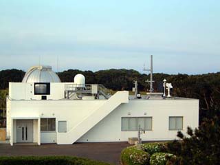
Tanegashima
Jump to: Photo, Contact, Coordinates, News, Links
Tanegashima Contact:
| Agency | Japan Aerospace Exploration Agency |
| Mailing Address | 305-8505 Sengen2-1-1 ,Tsukuba-city, Ibaraki |
| Primary Contact | |
| Contact Name | Shinchi Nakamura |
| Telephone (primary) | +81 50 3362 4798 |
| Telephone (secondary) | |
| Fax | |
| nakamura.shinichi@jaxa.jp | |
| Secondary Contact | |
| Contact Name | |
| Telephone (primary) | |
| Telephone (secondary) | |
| Fax | |
Tanegashima Coordinates:
Approximate Position:
| X coordinate | [m] | -3607651.5770 |
| Y coordinate | [m] | 4147873.7191 |
| Z coordinate | [m] | 3223722.5887 |
| Latitude | [deg] | 30.556509654 N |
| Longitude | [deg] | 131.01541710 E |
| Elevation | [m] | 141.0967 |
| Survey Method | ||
| Date Measured | ||
| Additional Information | Site is north of Launch site. | |
Tanegashima News:
Local Events:
No local events found.
SLRMail Messages:
No SLRMail mesages found.Tanegashima Link:
Tanegashima: Site Log
Instructions and Update Site Log
You can use the hyperlinks to quickly get to the section of interest or you can scroll down to read them all.
Section: 0. Form
Section: 1. Identification of the Ranging System Reference Point (SRP)
Section: 2. Site Location Information
Section: 3. General System Information
Section: 4. Telescope Information
Section: 5. Laser System Information
Section: 6. Receiver System
Section: 7. Tracking Capabilities
Section: 8. Calibration
Section: 9. Time and Frequency Standards
Section: 10. Preprocessing Information
Section: 11. Aircraft Detection
Section: 12. Meteorological Instrumentation
Section: 13. Local Ties, Eccentricities, and Collocation Information
Section: 14. Local Events Possibly Affecting Computed Position
Section: 15. On-Site, Point of Contact Agency Information
Section: 16. Responsible Agency (if different from 15.)
Section: 17. More Information
ILRS Site and System Information Form
International Laser Ranging Service
0. Form
Prepared by (Full Name) : Takehiro Matsumoto
Preparer E-mail : matsumoto.takehiro@jaxa.jp
Date Prepared : 2019-08-08
Report Type : UPDATE
Site Log Format Version : 2.0
Site Log Revision :
Back to top
1. Identification of the Ranging System Reference Point (SRP)
Site Name : Tanegashima (GUTS)
IERS DOMES Number : 21749S001
CDP Pad ID : 7358
Subnetwork : WPLTN
Description : Intersection of Axes of Telescope
Monument Description :
Monument Inscription :
Mark Description :
Date Installed : 2004-03-25
Date Removed :
Geologic Characteristic :
Additional Information : Correct the IERS DOMES Number and Description
Back to top
2. Site Location Information
City or Town : Tanegashima
State or Province : Kagoshima
Country : JAPAN
Tectonic Plate : Eurasian
Local Time (UTC +/- hours) :
Approximate Position
X coordinate [m]: -3607651.5770
Y coordinate [m]: 4147873.7191
Z coordinate [m]: 3223722.5887
Latitude [deg]: 30.556509654 N
Longitude [deg]: 131.01541710 E
Elevation [m]: 141.0967
Survey Method :
Date Measured :
Additional Information : Site is north of Launch site.
Back to top
3. General System Information
3.01 System Name : Tanegashima
4-Character Code : GMSL
CDP System Number : 89
CDP Occupation Number : 01
Eccentricity to SRP (if Not Identical With SRP)
North [m]:
East [m]:
Up [m]:
Date Measured :
Date Installed : 2004-03-25
Date Removed :
Additional Information : Correct the Eccentricity to SRP
Back to top
4. Telescope Information
4.01 Receiving Telescope Type : Coude
Aperture [m]: 1.0
Mount : AZ-EL
Date Installed :
Date Removed :
Xmitting Telescope Type : Coude
Aperture [m]: 1.0
Date Installed :
Date Removed :
Tracking Camera Type : 7 Telescope+CCD
Model : 20102
Manufacturer : QUESTAR
Field of View [deg]: 0.15
Minimum Magnitude [mag]: 13.5
Date Installed :
Date Removed :
Transmit/Receive Path : COMMON COUDE
Transmit/Receive Switch : POLARIZER
Max Slew Rate Az [deg/s]: 25
Max Slew Rate El [deg/s]: 10
Max Used Tracking Rate Az : 20
Max Used Tracking Rate El : 5
Telescope Shelter : Dome
Daylight Filter Type : Spectrum Filter
Dayl. Filt. Bandwidth [nm]: 0.38
Adjustable Attenuation : 0 to 6 ND
Adjustable Field of View :
Transmit Efficiency : 0.5
Receive Efficiency : 0.5
Date Installed : 2004-03-25
Date Removed :
Additional Information :
Back to top
5. Laser System Information
5.01 Laser Type : ND:YAG
Model :
Manufacturer :
Number of Amplifiers : 5
Primary Wavelength [nm]: 532.06
Primary Maximum Energy [mJ]: 50
Secondary Wavelength [nm]: NONE
Secondary Max. Energy [mJ]:
Xmit Energy Adjustable : NO
Additional Information :
Pulse Width (FWHM) [ps]: 50
Max. Repetition Rate [Hz]: 10
Fullw. Beam Divergence ["]: 3 - 25
Theoretical Beam Div :
Measured Beam Div :
Method Used :
Additional Information :
Final Beam Diameter [m]: 0.012 (Laser output), 0.8 (Telescope output)
Eyesafe : NO
Eyesafe Standard : ANSI 136.1-1976
Polarization on Exit :
Laser Fire Control :
Laser Energy Monitor :
Start Diode Type :
Manufactorer :
Model :
Quantum Efficiency [%]:
Rise/Fall Time [ps]:
Date Installed :
Date Removed :
Signal Processing :
Manufacturer :
Model :
Date Installed :
Date Removed :
Additional Information :
Date Installed : 2004-03-25
Date Removed :
Additional Information :
5.02 Laser Type : ND:YAG
Model :
Manufacturer :
Number of Amplifiers : 5
Primary Wavelength [nm]: 532.06
Primary Maximum Energy [mJ]: 250
Secondary Wavelength [nm]: NONE
Secondary Max. Energy [mJ]:
Xmit Energy Adjustable : NO
Additional Information :
Pulse Width (FWHM) [ps]: 250
Max. Repetition Rate [Hz]: 10
Fullw. Beam Divergence ["]: 3 - 25
Theoretical Beam Div :
Measured Beam Div :
Method Used :
Additional Information :
Final Beam Diameter [m]: 0.012 (Laser output), 0.8 (Telescope output)
Eyesafe : NO
Eyesafe Standard : ANSI 136.1-1976
Polarization on Exit :
Laser Fire Control :
Laser Energy Monitor :
Start Diode Type :
Manufactorer :
Model :
Quantum Efficiency [%]:
Rise/Fall Time [ps]:
Date Installed :
Date Removed :
Signal Processing :
Manufacturer :
Model :
Date Installed :
Date Removed :
Additional Information :
Date Installed : 2004-03-25
Date Removed :
Additional Information :
Back to top
6. Receiver System
6.01.01 Primary Chain
Wavelength [nm]: 532
Detector Type : MCP-PMT
Manufacturer : Photek
Model : PMT210
Quantum Efficiency [%]: 12
Nominal Gain : 1e6
Rise Time [ps]: 100
Jitter (Single PE)[ps]: 20 - 30
Field of View Diam ["]: 120
Date Installed : 2005-08-01
Date Removed :
Amplifier Type :
Manufacturer :
Model :
Gain :
Bandwidth :
Date Installed :
Date Removed :
Additional Information:
Signal Processing : CFD Discriminator
Manufacturer : Oxford Instruments, Inc.
Model : TC 454
Date Installed : 2004-03-25
Date Removed :
Amplitude Measurement : YES
Return-Rate Controlled:
Mode of Operation :
Additional Information:
Time of Flight Observ. : EVENT TIMER
Manufacturer : Honeywell Technology
Model :
Resolution [ps]: 4
Precision [ps]: 5
Date Installed : 2004-03-25
Date Removed :
Additional Information : The amplitude measurements are made
: using a Peak Amplitude Detector
: Honeywell Technology manufactered
6.02.01 Secondary Chain
Wavelength [nm]:
Detector Type :
Manufacturer :
Model :
Quantum Efficiency [%]:
Nominal Gain :
Rise Time [ps]:
Jitter (Single PE)[ps]:
Field of View Diam ["]:
Date Installed :
Date Removed :
Amplifier Type :
Manufacturer :
Model :
Gain :
Bandwidth :
Date Installed :
Date Removed :
Additional Information:
Signal Processing :
Manufacturer :
Model :
Date Installed :
Date Removed :
Amplitude Measurement :
Return-Rate Controlled:
Mode of Operation :
Additional Information:
Time of Flight Observ. :
Manufacturer :
Model :
Resolution [ps]:
Precision [ps]:
Date Installed :
Date Removed :
Additional Information :
6.03.01 Tertiary Chain
Wavelength [nm]:
Detector Type :
Manufacturer :
Model :
Quantum Efficiency [%]:
Nominal Gain :
Rise Time [ps]:
Jitter (Single PE)[ps]:
Field of View Diam ["]:
Date Installed :
Date Removed :
Amplifier Type :
Manufacturer :
Model :
Gain :
Bandwidth :
Date Installed :
Date Removed :
Additional Information:
Signal Processing :
Manufacturer :
Model :
Date Installed :
Date Removed :
Amplitude Measurement :
Return-Rate Controlled:
Mode of Operation :
Additional Information:
Time of Flight Observ. :
Manufacturer :
Model :
Resolution [ps]:
Precision [ps]:
Date Installed :
Date Removed :
Additional Information :
Back to top
7. Tracking Capabilities
7.01 Satellites
Very Low Alt (<400 km) : YES
Low Altitude (400-2000) : YES
LAGEOS/LARES : YES
GLONASS : YES
Etalon : YES
GNSS : YES
Geosynchronous :
Moon : NO
Ave. Pass Switch Time [s]: 30
Average values for LAGEOS
Single Shot RMS [mm]: 5
# of Obs per NP :
Use of Semi-trains : NO
# of Semi-train Tracks : N.A.
Range Gate Width [ns]: 1000 - 10000
Beam Pointing Accuracy ["]: 2
Angle Encoder Resolution["]: 0.02
Min. Tracking Elev. [deg]: 20
Laser Polarization @emitter:
Operation
Months per Year : 12
Days per Week : 7
Hours per Day : 24
Staff per Shift : 1 - 2
System Shared With : none
Time Allocated to SLR [%]: 100
Remotely Controllable : YES
Tracking Restrictions
Go/No-go flag :
Satellite Verification :
Date Verified :
Maximum elevation :
Satellite Verification :
Date Verified :
Pass segments :
Satellite Verification :
Date Verified :
Schedule segments :
Satellite Verification :
Date Verified :
Maximum laser power limit:
Satellite Verification :
Date Verified :
Date First Applicable : 2004-03-25 00:00 UT
Date Last Applicable :
Additional Information :
Back to top
8. Calibration
8.01 Calibration Type : PRE+POST
Target Location : INTERNAL+EXTERNAL
Target Type : Corner Cube
Target Structure : INT corner cube behind the secondary mirror
: EXT concrete pier
Number of Targets :
Target Distance(s) [m]: 13, 68, 83
Date Measured :
Accuracy [mm]: <1
Verification : Survay comparison with external target
Return-Rate Controlled : N.A.
Eye-Safe Method :
Additional Information :
Mode of Operation : N.A
Calibration performed : 60
Single Shot RMS [mm]: 1.3
Edit Criterion 1st Chain : ITERATIVE 3.0 SIGMA
Edit Criterion 2nd Chain : ITERATIVE 3.0 SIGMA
Application of Cal Data : AVERAGE over pass
Date Installed :
Date Removed :
Additional Information :
Back to top
9. Time and Frequency Standards
9.01.01 Frequency Standard Type : CESIUM
Model : HP5071
Manufacturer : H.P.
Short Term Stab. [e-12]: 0.5
Long Term Stab. [e-12]: 0.01
Time Reference : GPS
Synchronization : GPS
Epoch Accuracy [ns]: 100
Date Installed : 2004-03-25
Date Removed :
Additional Information :
9.02.01 GNSS Timing Rcvr Model : XL-DC
Manufacturer : TrueTime
Date Installed : 2004-03-25
Date Removed :
Additional Information :
9.03.01 One-way System Calibration
Date performed :
Direction Calibrated :
Additional Information :
Back to top
10. Preprocessing Information
10.01 On-site NP Generation : YES
Data Screening : NUMERICAL INTEGRATION and GAUSSIAN FIT
Return-Rate Rejection :
Edit Criterion 1st Chain : ITERATIVE 3.0 SIGMA
Edit Criterion 2nd Chain : ITERATIVE 3.0 SIGMA
Upload interval : After each pass
Date First Applicable :
Date Last Applicable :
Additional Information :
Back to top
11. Aircraft Detection
11.01 Detection Type : RADAR
Manufacturer/Provider :
Automatic Laser Shutoff :
Alarms Recorded :
Hazard Distance [km]:
Date Installed :
Date Removed :
Additional Information :
Back to top
12. Meteorological Instrumentation
12.01.01 Pressure Sensor Model : RPT-301
Manufacturer : NIPPON ELECTRIC INSTRUMENT
Recording Interval : 00:01:00
Accuracy [mbar]: 0.1
Height Diff to SRP [m]: 0 (TBD)
Distance from SRP [m]:
Date Installed : 2004-03-25 00:00 UT
Calibration Interval : Every one year
Date Removed :
Additional Information :
12.02.01 Temp Sensor Model : N-65B
Manufacturer : NIPPON ELECTRIC INSTRUMENT
Recording Interval : 00:01:00
Accuracy [deg C]: 0.2
Date Installed : 2004-03-25 00:00 UT
Calibration Interval : Every one year
Date Removed :
Additional Information :
12.03.01 Humidity Sensor Model : HMP45D
Manufacturer : NIPPON ELECTRIC INSTRUMENT
Recording Interval : 00:01:00
Accuracy [% rel h]: 2
Date Installed : 2004-03-25 00:00 UT
Calibration Interval : Every one year
Date Removed :
Additional Information :
Back to top
13. Local Ties, Eccentricities, and Collocation Information
13.01 Collocated Permanent Geodetic Systems
13.01.01.01 GNSS : YES
Date Installed : 2003-08-26
Date Removed :
Additional Info : GPS data provide to the IGS as a name of GMSD
13.01.01.02 GNSS :
Date Installed :
Date Removed :
Additional Info :
13.01.02.01 DORIS : NO
Date Installed :
Date Removed :
Additional Info :
13.01.03.01 PRARE : NO
Date Installed :
Date Removed :
Additional Info :
13.01.04.01 VLBI : NO
Date Installed :
Date Removed :
Additional Info :
13.01.05.01 Gravimeter : NO
Date Installed :
Date Removed :
Additional Info :
13.01.06.01 Other SLR :
Date Installed :
Date Removed :
Additional Info :
13.02.01.01 Local Ties from the SRP to Other Monuments or Systems on Site
Monument Name : HAC GPS station (GMSD)
Instrumentation Type : GPS
Instrumentation Status : PERMANENT
DOMES Number : 21749S002
CDP Number : N.A.
Differential Components (ITRS)
dx [m]: 13.8533 +- 0.0003
dy [m]: 5.4943 +- 0.0003
dz [m]: 5.327 +- 0.0003
Date Measured : 2012-02-25
Determined by : 2012-04-13
Date Installed : 2012-04-13
Date Removed :
Additional Information : IGS permanent station
: x=-3607665.4303
: y=4147868.2248
: z=3223717.2617
13.03.01.01 Eccentricities Between Other Monuments on Site
From: Monument Name :
DOMES Number :
CDP Number :
To: Monument Name :
DOMES Number :
CDP Number :
Differential Components (ITRS)
dx [m]:
dy [m]:
dz [m]:
Date Measured :
Determined by :
Additional Information :
Back to top
14. Local Events Possibly Affecting Computed Position
14.01 Date :
Event :
Additional Information :
Back to top
15. On-Site, Point of Contact Agency Information
Agency : Japan Aerospace Exploration Agency
Mailing Address : 305-8505 Sengen2-1-1 ,Tsukuba-city, Ibaraki
Website :
Primary Contact
Contact Name : Shinchi Nakamura
Telephone (primary) : +81 50 3362 4798
Telephone (secondary) :
Fax :
E-mail : nakamura.shinichi@jaxa.jp
Secondary Contact
Contact Name : Takehiro Matsumoto
Telephone (primary) : +81 50 3362 5276
Telephone (secondary) :
Fax :
E-mail : matsumoto.takehiro@jaxa.jp
Tertiary Contact
Contact Name :
Telephone (primary) :
Telephone (secondary) :
Fax :
E-mail :
Additional Information : Operation of GUTS-SLR will be performed by
: remote control from Tsukuba Space Center.
: Maintenance staff redides at the local site.
Back to top
16. Responsible Agency (if different from 15.)
Agency :
Mailing Address :
Primary Contact
Contact Name :
Telephone (primary) :
Telephone (secondary) :
Fax :
E-mail :
Secondary Contact
Contact Name :
Telephone (primary) :
Telephone (secondary) :
Fax :
E-mail :
Additional Information :
Back to top
17. More Information
URL for More Information : http://god.tksc.nasda.go.jp/
: slrsub/boring.html
Hardcopy on File
Site Map : YES
Site Diagram :
Horizon Mask : YES
Monument Description : YES
Site Pictures : YES
Additional Information :
Back to top
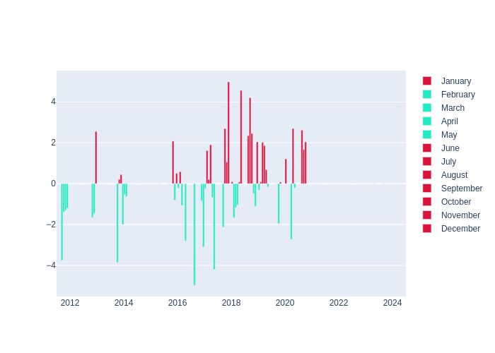
Tanegashima: Meteorological data
Note: For a larger view, please select a thumbnail.
| Type | Since 2012 | Monthly Average Offset |
|---|---|---|
| Temperature | 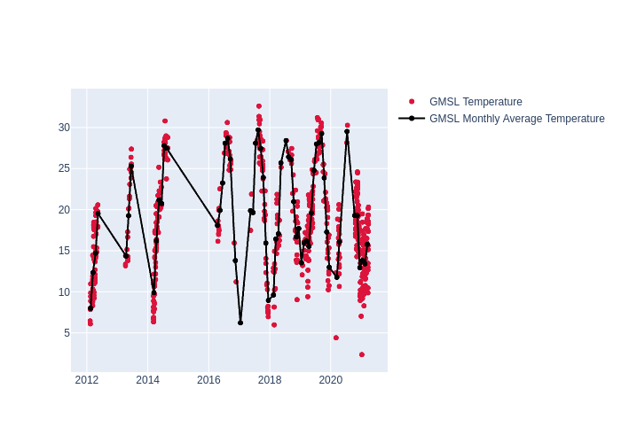 |
 |
Humidity | 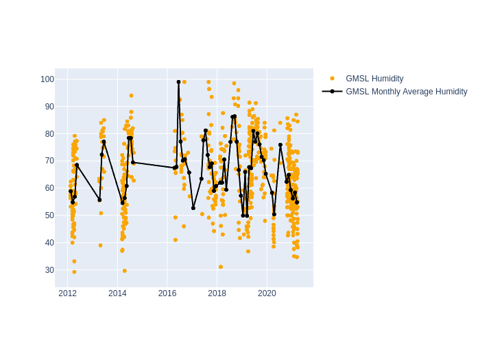 |
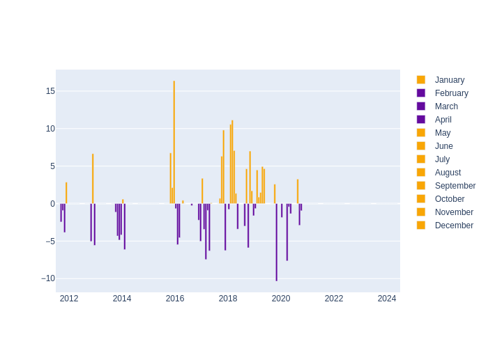 |
| Pressure | 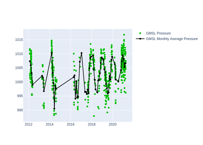 |
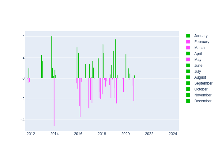 |
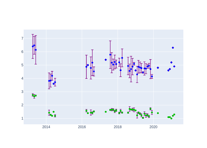
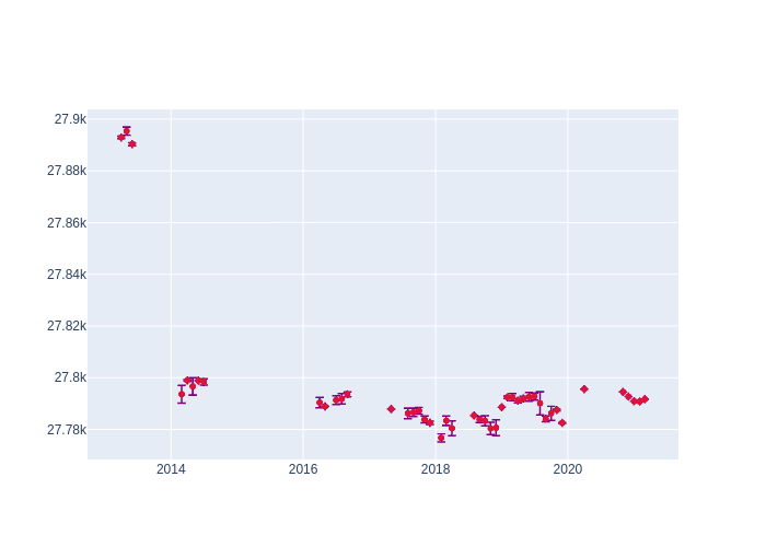
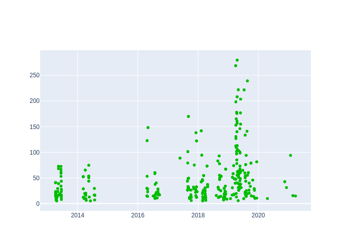
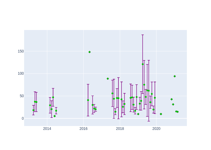
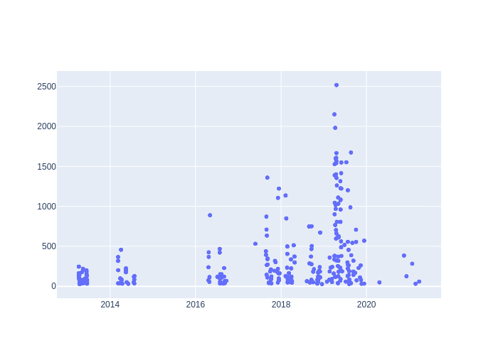
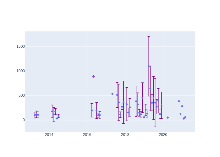
Tanegashima: LAGEOS performance
Note: For a larger view, please select a thumbnail.
| type | Since 2012 | Monthly average |
|---|---|---|
| RMS | 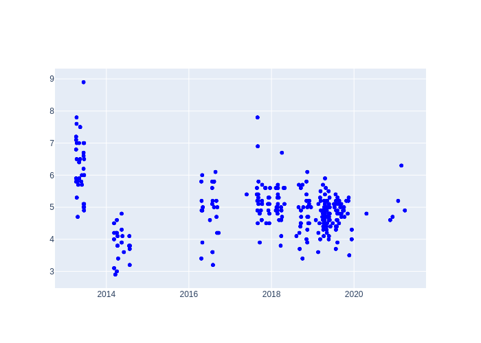 |
 |
| Cal RMS | 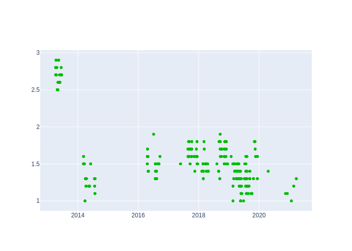 |
|
| Sys Dly | 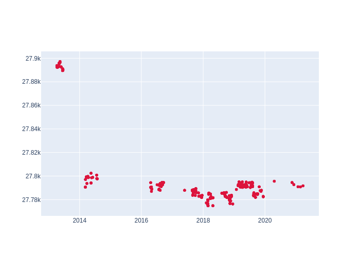 |
 |
| Obs per NPT |
 |
 |
| FR Obs per Pass |
 |
 |
Tanegashima: 7-day tracking information
Click on a plot to view a larger image.
| Days ago | |
|---|---|
| 1 | |
| 2 | |
| 3 | |
| 4 | |
| 5 | |
| 6 | |
| 7 |
Tanegashima: Satellite Information (as a function of local time and satellite range)
Click on a plot to view a larger image.
| satellite | local time | range | ||
|---|---|---|---|---|
| npt rms | numFR /npt | npt rms | numFR /npt |
|
| Ajisai 30 sec |
 |
 |
 |
 |
| Cryosat-2 15 sec |
 |
 |
 |
 |
| Etalon-1 300 sec |
 |
 |
 |
 |
| Etalon-2 300 sec |
 |
 |
 |
 |
| Galileo-102 300 sec |
 |
 |
|
 |
| Galileo-202 300 sec |
 |
 |
|
 |
| Galileo-209 300 sec |
 |
 |
|
 |
| Galileo-210 300 sec |
 |
 |
|
 |
| GLONASS-131 300 sec |
 |
 |
 |
 |
| GLONASS-134 300 sec |
 |
 |
 |
 |
| GLONASS-138 300 sec |
 |
 |
 |
 |
| GLONASS-139 300 sec |
 |
 |
 |
 |
| GRACE-FO-1 5 sec |
 |
 |
 |
 |
| GRACE-FO-2 5 sec |
 |
 |
 |
 |
| Jason-3 15 sec |
 |
 |
 |
 |
| LAGEOS-1 120 sec |
 |
 |
 |
 |
| LAGEOS-2 120 sec |
 |
 |
 |
 |
| LARES 30 sec |
 |
 |
 |
 |
| Starlette 30 sec |
 |
 |
 |
 |
| Stella 30 sec |
 |
 |
 |
 |
| Swarm-A 5 sec |
 |
 |
 |
 |
| Swarm-B 5 sec |
 |
 |
 |
 |
| Swarm-C 5 sec |
 |
 |
 |
 |

- NASA Official: Frank Lemoine
- Web Developers: 610 Web Dev
- Contact Us
- Last modified date: Jun 23, 2023
- Privacy Policy & Important Notices